- Home
- /
- Gravel Adventure Field Guide
- /
- Alamosa
Founded on the Rio Grande River in 1878, the town serves as a hub for the entire valley due to its central location. Alamosa’s name signifies “cottonwood groves” in Spanish. Similar to other SLV communities, its settlement was directly related to the arrival of the railroad as a result of mining discoveries in the San Juan Mountains to the west. This led to an expanded farming, ranching, and timber economy that persists even now. Alamosa’s central location makes it an ideal base to explore the valley’s abundance of gravel riding, including the Great Sand Dunes area.
Routes
Wildlife Refuge
Distance: 40 Miles
Elevation: +270 Ft
Max Grade: 1.1%
Approx: 58/42 %Gravel/Paved
This is a classic San Luis Valley route highlighting symbiotic relationships of land, water, and wildlife in south-central Colorado. Leaving south from Alamosa, the first 10 miles are paved before giving way to a long stretch of dirt. This ride circumnavigates the Alamosa Wildlife Refuge, which was established in 1963 to protect 12,025 acres of habitat for migratory birds and valley wildlife.
What makes this ride special is the high probability of seeing one of over 200 bird species, including songbirds, water birds, waterfowl and raptors. Prancing mule deer, beavers, and howling coyotes are part of the experience, as well. Be prepared for weak cell phone signals at times, and expect to encounter short sections of sand. Appreciate the solitude while taking in views of three mountain ranges: the Sangres to the east, San Juans to the west, and Saguache mountains to the north.
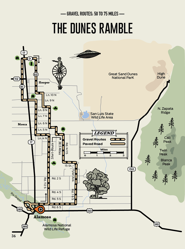
Dunes Ramble
Distance: 69 Miles
Elevation: +186 Ft
Max Grade: 0.4%
Approx: 84/16 %Gravel/Paved
Traveling northeast from the town of Alamosa, the majestic Blanca Peak stares at you. Throw in the Great Sand Dunes on the horizon and the view makes for a fantastic gravel ride. Even though there’s no climbing, don’t expect an easy ride. Rambling over low rolling sections of road makes this a fast training ride option, or fun low key ride distance. You can add to the ride and swing by the UFO Watch Tower in Hooper.
Always take into consideration wind conditions, because they can add a challenge. Remember, wind played a key role in the formation of the dunes. Places where wind moves grains of sand are considered aeolian environments. Here, the wind blows towards the Sangre de Cristo mountains, and storms bring it back toward the valley. The opposing air flow is what causes the dunes to grow upward in size.
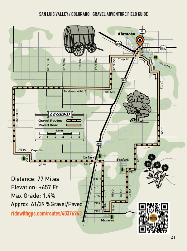
Valley Farm Tour
Distance: 77 Miles
Elevation: +657 Ft
Max Grade: 1.4%
Approx: 61/39 %Gravel/Paved
This is another route with a mellow elevation profile that demonstrates the role agriculture plays in the SLV way of life. Long stretches of dirt, magnificent mountain views, historical sites, and towns along the way make this long distance ride special.
Highlights include riding past Pike’s Stockade, where Zebulon Pike built one of the first structures built by an American in Colorado. Nearby Manassa is the birthplace of former boxing champion Jack Dempsey. In La Jara, the historic train depot (1911) shipped ranch and farm products and is now the town hall. Meanwhile, Capulin is the former home of Hispanic folk textile artist Eppie Archuelta, who owned and operated the SLV Wool Mill.
Countless farms and ranches further illustrate the multi-ethnic heritage and storytelling of the valley. In 1870, Hispano sheepherders welcomed Mormon immigrants who helped improve farming techniques, and in recent years the Amish have added to the multiculturalism of the valley.